In Range Is Not Enough: Can Your Aircraft Actually Land There?
Lose an engine over the middle of the Pacific and the map gets very simple: you turn toward the nearest airport that can take you. But "nearest airport" is a trap. An alternate is only useful if the aircraft can actually land there, on a runway that is both long enough and hard enough to stop a loaded jet. Great Circle Pro now checks exactly that.
Every twin engine crew that flies over water carries a running answer to one quiet question: if an engine quits right now, where do I go? The answer is never "somewhere." It is always a specific airport, and the rules that decide which airports count are strict. This is the world of ETOPS, and Great Circle Pro just made its diversion analysis meaningfully smarter about it.
Until now, our ETOPS check asked one thing of every diversion airport: is it within reach on one engine? If a field sat inside the one engine inoperative (OEI) diversion radius, it counted as coverage. That is the geometry half of the problem, and it is the half most tools stop at. But reach is not the same as landing. A field can be perfectly in range and still be useless to you, because the runway is too short, or it is gravel, or it is a floatplane pond. The new release closes that gap: an alternate now only covers your route if the aircraft can actually put its wheels down there.
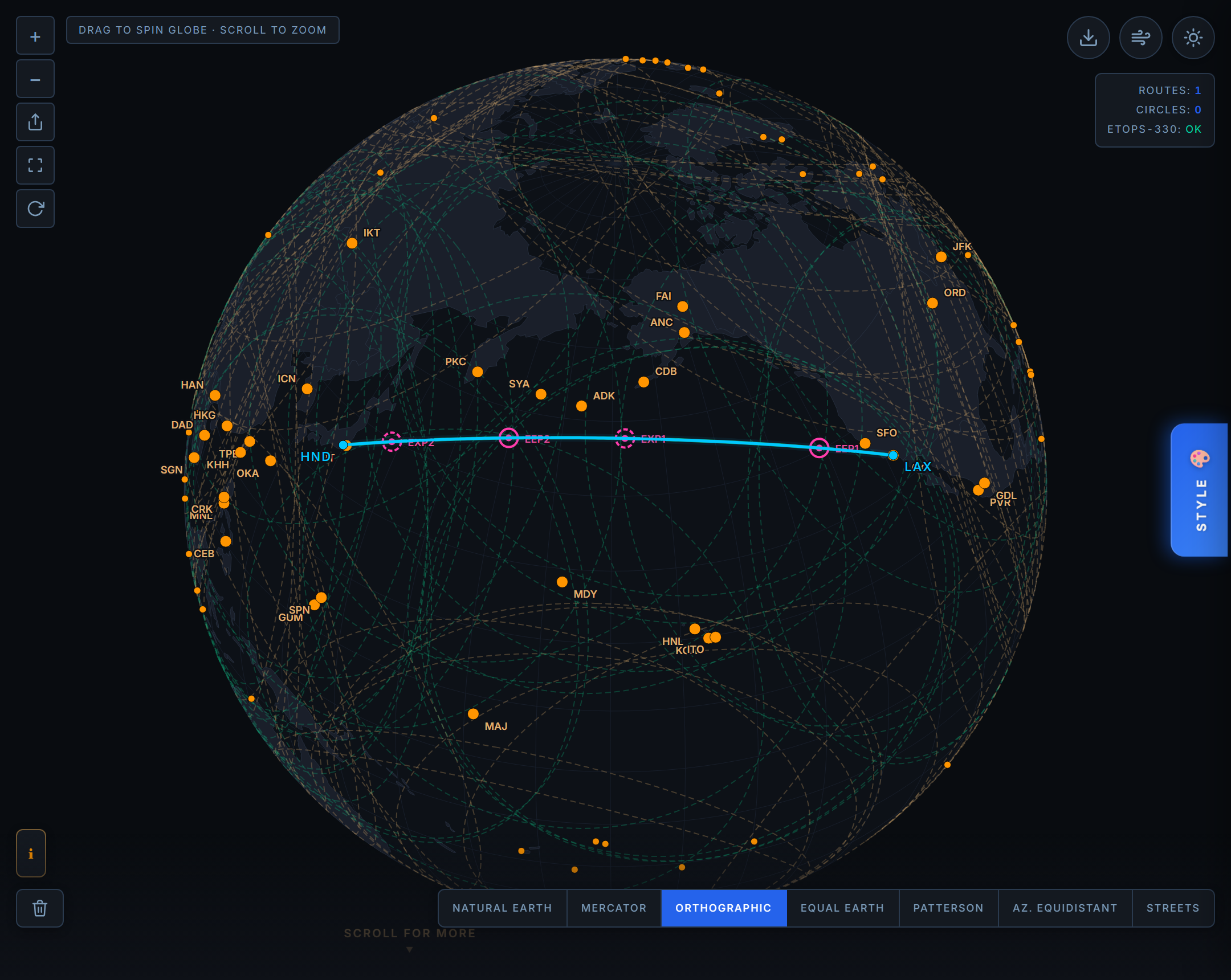
A Los Angeles to Tokyo Haneda great circle on a 787-9 at ETOPS 330. The ring of North Pacific and Aleutian alternates carries the route, and every one of them is now checked for a runway the 787 can actually use.
What Makes an Alternate "Adequate"
In the regulations, the word for a usable diversion airport is adequate, and it means far more than "an airport exists here." An adequate alternate has to have a runway long enough and suitable for the specific aeroplane. It has to be expected to be open, with weather at or above its alternate minima. It has to offer the required services, including a rescue and firefighting category appropriate to the aircraft. Runway length and surface are not a footnote in that definition. They are load bearing. If you want the full picture of how the ratings and the diversion radius fit together, we wrote a companion piece on how ETOPS ratings and diversion math actually work.
A check that looks only at range quietly assumes every airport on the map is adequate. For the classic ocean crossing alternates that assumption usually holds, because those fields were built or kept open for exactly this purpose. But "usually" is not a standard you want inside a safety calculation, and it falls apart the moment you point the tool at a smaller aircraft, a sparse region, or a field nobody has personally vetted.
Two Tests, Not One
Coverage in Great Circle Pro is now two independent tests, and an alternate has to pass both.
First, range. Can the aircraft reach the field on one engine, within its ETOPS rating, at OEI cruise speed, against a conservative wind? That is the radius test we have always run.
Second, landing. Does the field have a hard, paved runway at least as long as that particular aircraft's required landing distance? Grass, gravel, dirt, and water do not qualify. A runway that is paved but too short does not qualify either.
The important word is independent. A field can pass one test and fail the other, and the two failures mean very different things in the cockpit. An airport that is out of range is simply too far away. An airport that is in range but cannot land your aircraft is close enough to reach and no help at all, which is arguably the more dangerous illusion, because a tool that looked only at range would have painted it green.
The whole idea in one line. Reach is a geometry problem. Landing is a performance problem. A real diversion airport has to solve both, and until now the tool only graded the first.
Why the Runway Requirement Changes With the Aircraft
Required landing distance is not one number. It belongs to the airframe, and it moves with weight, speed, and the surface under the wheels.
Weight is the big driver. A jet that has just lost an engine two hours into a long crossing is heavy, because it has not burned down the fuel it planned to burn. It may be near its maximum landing weight, sometimes heavy enough that the crew has to weigh an overweight landing against dumping or burning fuel first. Heavy means fast: a higher approach speed, more energy to dissipate, more concrete to do it on. A widebody crossing an ocean at high weight simply needs more runway than the same type landing light.
Then there is the surface. A dry, grooved runway stops an aircraft far better than a wet or contaminated one, and an unpaved strip is not even in the conversation. A loaded transport category jet cannot reliably stop on gravel or dirt, and most are not certified to try. That is why the tool treats a hard surface as a hard requirement, not a preference.
The result is a required landing distance that ranges widely by type. Here is the spread the tool uses, from the widebodies down to a business jet, as representative dry landing lengths near maximum landing weight:
| Aircraft | Runway needed to land |
|---|---|
| Boeing 777-300ER | 7,000 ft |
| Boeing 777-9 | 6,800 ft |
| Airbus A350-1000 | 6,400 ft |
| Boeing 787-9 | 6,100 ft |
| Airbus A320neo | 5,300 ft |
| Boeing 737 MAX 8 | 5,200 ft |
| Airbus A318 | 4,300 ft |
| Bombardier Global 7500 | 2,800 ft |
These are planning estimates, not certified dispatch numbers, and the tool says so plainly. A real dispatch release accounts for the actual landing weight, the actual runway, its slope and contamination, the wind, and the temperature. What the tool gives you is a sound first cut: enough to know whether a field is even in the running. You can see the full set of types and their figures in the aircraft database.
Notice the spread in that table. The heaviest widebody, the 777-300ER, wants 7,000 ft. The Global 7500, a business jet built for exactly these long over water legs, is happy with 2,800 ft. A gravel strip that is a genuine lifeline for a light jet is no option at all for a loaded twin aisle jet, and a check that looked only at range would have treated the two as equals.
Teal, Amber, and Red
On the map, every ETOPS alternate now carries one of three colors, and the middle one is new.
Teal means covered. The field is in range and the aircraft can land there. This is the state you want to see marching along your route.
Amber is the new state. The airport is inside your OEI diversion reach, but its longest runway cannot land this aircraft. Reachable, but not usable. Amber is the color of a false sense of security caught before it can hurt you: the field a range check alone would have called good.
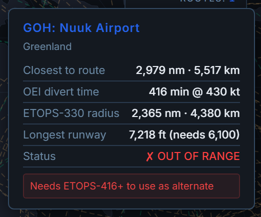
Red means out of range. Too far to reach on one engine within the rating, no matter how long its runway is.
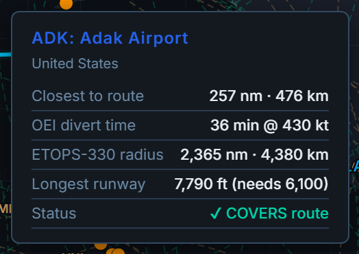
Hover any alternate and the tool shows you the arithmetic directly: "Longest runway X ft (needs Y)." There is no guessing about why a field came out amber or teal. You see its longest runway and the length this aircraft needs, side by side, on every field on the map.
The Islands That Exist for This
It is worth pausing on Adak, because it is no accident that it works.
Look at where twins actually cross open ocean and you find a short list of lonely airports doing enormous quiet work. Across the North Atlantic it is Gander and Goose Bay in Canada, Keflavik in Iceland, Shannon on the Irish coast. Across the North Pacific and up through the Aleutians it is Anchorage, Cold Bay, Adak, Shemya, and out toward Asia, Midway and Petropavlovsk. These are the stepping stones that make oceanic twin operations legal, and several of them exist for essentially one reason: a twin over open water has nowhere else to go, so someone keeps a long, hard runway lit at the edge of nowhere.
Adak is the purest example. It is a former naval air station on a remote island far out in the Aleutian chain, with weather that can be genuinely hostile and a runway near 7,790 ft of pavement. Almost nobody lives there. It stays a viable ETOPS alternate because the geometry of the Pacific demands it. When the tool paints Adak teal on a Los Angeles to Tokyo route, it is confirming that this particular island, on this particular day, with this particular aircraft, is genuinely a place you could set the airplane down. That is the entire point of checking the runway and not just the range. I have flown the King Air and the Citation, nothing near a loaded 787, and even in a light jet the question "is that runway long enough, today, at this weight" is never academic.
What This Changes Today, Honestly
Here is the honest accounting, because a tool that oversells itself is not worth trusting.
Great Circle Pro's curated ETOPS alternate network is 141 major diversion airports, and every one of them is paved and at least 7,218 ft long. The heaviest landing requirement in the current fleet is the 777-300ER at 7,000 ft. Do the subtraction: on today's standard alternate set, with today's aircraft, the runway gate excludes nothing. Every curated alternate clears every current type with room to spare. This feature is not, right now, flipping ETOPS verdicts on the world's main diversion fields, and we are not going to pretend it is.
So what does it actually buy you today? Two things. First, protection you cannot get any other way. The moment you analyze a smaller or lighter aircraft against a sparser region, or the moment a shorter or unpaved field enters the alternate set, the gate is already there and already correct. The tool can never again quietly call a too short or unpaved airport an adequate alternate. That failure mode is closed for good. Second, transparency. Every alternate now shows you its longest runway and the length your aircraft needs, on hover, for every field on the map. Even when the answer is "yes, obviously," you can see why, instead of taking it on faith.
That is a modest, honest win, and it is the right kind: not a headline that the standard network suddenly fails, but a floor under the analysis that was not there before, and a runway readout on every field.
Where the Runway Data Comes From
The runway numbers come from OurAirports, a public domain database of airports worldwide. Great Circle Pro carries runway data for about 8,500 airports, roughly 70% of the 12,175 the tool knows about. That is not really a gap in coverage so much as a fact about airports: the other 30% are heliports, seaplane bases, and ground stations that have no runway to measure. Every field that actually has a runway has its length in the tool.
We checked the lengths against well known fields and they hold up: John F Kennedy (JFK) at 14,511 ft, Denver (DEN) at 16,000 ft, and London City (LCY) at 4,948 ft, the short urban runway that famously keeps the largest jets out. Accurate length data is the whole foundation of the landing check, so it was worth verifying before we shipped.
Common Questions
What does it mean for an ETOPS alternate to be "adequate"?
An adequate alternate is far more than an airport that happens to be in reach. Regulations require a runway long enough and suitable for the specific aeroplane, weather expected to be at or above alternate minima, and the required services such as an appropriate rescue and firefighting category. Great Circle Pro's new check models the runway length and surface part of that definition.
Why does required landing distance depend on the aircraft?
Landing distance scales with weight, approach speed, and runway surface. A diverting jet is often near its maximum landing weight because it has not burned down its fuel, which means a faster approach and more runway to stop. A heavy widebody like the 777-300ER needs about 7,000 ft, while a business jet like the Global 7500 is happy with about 2,800 ft.
What do the teal, amber, and red alternates mean on the map?
Teal means the field is covered: in one engine inoperative range and landable by your aircraft. Amber means it is inside your diversion reach but its longest runway is too short for this aircraft, so it is reachable but not usable. Red means it is out of range entirely, no matter how long its runway is.
Does this feature change ETOPS verdicts on normal ocean routes today?
Not on the standard network. Great Circle Pro's curated set of 141 major diversion airports is all paved and all at least 7,218 ft, and the heaviest current requirement is the 777-300ER at 7,000 ft, so nothing is excluded today. The value right now is protection against a shorter or unpaved field or a smaller aircraft, plus a runway readout on every alternate.
Can a loaded jet land on a gravel or dirt runway in a diversion?
As a rule, no. A loaded transport category jet cannot reliably stop on an unpaved surface and most are not certified for it, which is why the tool requires a hard, paved runway. Grass, gravel, dirt, and water alternates do not count as landable.
Where does Great Circle Pro get its runway data?
Runway lengths come from OurAirports, a public domain database. The tool carries runway data for about 8,500 airports, roughly 70% of its 12,175, which is every airport that actually has a runway; the rest are heliports, seaplane bases, and ground stations. Verified examples include JFK at 14,511 ft and Denver at 16,000 ft.
Is the tool's landing distance a legal dispatch number?
No. The figures are planning estimates near maximum landing weight on a dry runway, and the tool labels them as such. A real dispatch release accounts for the actual weight, runway slope and contamination, wind, and temperature, so use the tool to understand the geometry, not to file a flight.
Why is Adak an ETOPS alternate if almost nobody lives there?
Adak exists as a diversion field because of geography. A twin crossing the North Pacific has very few places to go, so a long, hard runway far out in the Aleutians is kept viable for exactly that need. With a runway near 7,790 ft, it comfortably accepts a 787-9, which needs about 6,100 ft.