The 10 Longest Flights in the World, Mapped
Tonight, somewhere over the Arctic Ocean, a Singapore Airlines A350 will pass closer to the North Pole than most polar expeditions ever get. Its passengers boarded in the tropics, one degree north of the equator. They will land in New York, which sits level with Madrid. Nothing on that ticket says Arctic, and yet the shortest path between those two cities runs almost directly over the top of the planet. That is the strange, beautiful geometry behind the world's longest flights. Here are the ten longest nonstops, mapped the way the Earth actually works, with the aircraft that fly them and the physics that decides where the list ends.
The Ten Longest Nonstop Flights
Ranked by great circle distance, the pure geometry between the two airports. Schedules shift and airlines swap metal, but the geometry never moves, which makes it the honest way to rank routes. Block times are approximate for the longer direction and vary by season and winds.
| # | Route | Great circle | Aircraft | Block time |
|---|---|---|---|---|
| 1 | Singapore (SIN) to New York JFK | 8,283 nm · 15,340 km | A350-900ULR | about 18h 45m |
| 2 | Singapore (SIN) to Newark (EWR) | 8,280 nm · 15,335 km | A350-900ULR | about 18h 30m |
| 3 | Doha (DOH) to Auckland (AKL) | 7,848 nm · 14,535 km | 777-200LR | about 17h 30m |
| 4 | Perth (PER) to London (LHR) | 7,833 nm · 14,507 km | 787-9 | about 17h 20m |
| 5 | Auckland (AKL) to New York JFK | 7,675 nm · 14,215 km | 787-9 | about 17h 30m |
| 6 | Auckland (AKL) to Dubai (DXB) | 7,668 nm · 14,202 km | A380 | about 17h 15m |
| 7 | Los Angeles (LAX) to Singapore (SIN) | 7,614 nm · 14,101 km | A350-900ULR | about 17h 50m |
| 8 | San Francisco (SFO) to Bengaluru (BLR) | 7,553 nm · 13,988 km | 777-200LR | about 17h 30m |
| 9 | Houston (IAH) to Sydney (SYD) | 7,471 nm · 13,836 km | 787-9 | about 17h 30m |
| 10 | Dallas Fort Worth (DFW) to Sydney (SYD) | 7,456 nm · 13,808 km | A380 / 787-9 | about 17h 10m |
Distances computed as pure great circles between airport coordinates, the same math the map tool uses.
Why the Longest Flight Almost Touches the North Pole
Singapore sits one degree north of the equator. New York sits at forty. Draw the route on a classroom wall map and instinct runs a line east across the Pacific, past Hawaii, and instinct is wrong by well over a thousand miles. The real shortest path leaves Singapore pointing almost due north. It climbs over China, crosses Siberia, brushes 87.3 degrees north, about 160 nautical miles from the North Pole, then falls down the other side of the world through the Canadian Arctic and into New York. The departure heading is 357 degrees. The airplane aims just west of true north and the destination simply arrives on the far side of the planet's ceiling.
None of this is a detour. It only looks like one because a flat map has to stretch the globe somewhere, and the popular projections stretch it hardest at the poles. Flatten the Earth and the honest path gets bent into a strange arc that hugs the top of the chart, while the line that looks straight quietly becomes the long way around. Every seatback map on an ultra long haul flight is quietly fighting this distortion.
Both lines connect the same two airports. The curve that hugs the top of the map is the shorter one.
Now remove the distortion
Here is the same route with the trick undone. This is a real screenshot from Great Circle Pro's orthographic globe, looking straight down at the North Pole. The mysterious arc is gone. Seen from above the top of the world, the longest flight on Earth is very nearly a straight line, and the pole sits just off its left shoulder.
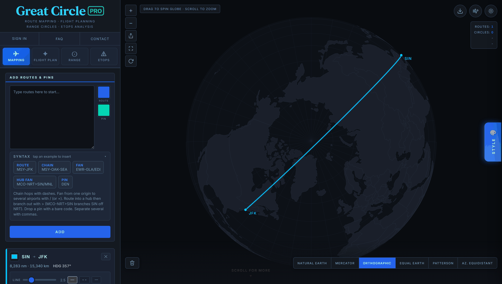
Straight down on the North Pole, the 8,283 nm route barely bends. Route card: 8,283 nm, heading 357°.
Try it yourself in ten seconds. Open gcpromap.com/?r=SIN-JFK and the route draws itself. Click Orthographic in the projection bar, then drag the globe until you are looking down on the Arctic. Watch the curve straighten out as you spin. Then glance at the route card: heading 357 degrees, almost due north, for a city on the far side of the world. The full theory of why flat maps do this, and when navigators deliberately fly the "wrong" straight line, is in our great circle vs rhumb line explainer.
The Longest Flight Is Not Always the Longest Route
Great circle distance is geometry. Flown distance is politics and weather. Cathay Pacific's New York to Hong Kong service is "only" about 7,000 nautical miles by geometry, far short of this list's top tier. But with Russian airspace closed, its westbound routing has at times crossed the Atlantic and continental Asia instead of the Pacific, producing some of the longest flown distances in scheduled service, beyond even Singapore to New York's track miles.
That gap between the geometric route and the filed one is exactly why a serious planning tool has to model airspace. Our airspace avoidance explainer covers how closures reroute the world's long haul flows, and the Flight Plan tab's closed airspace toggle draws the detour and recomputes time and fuel against the longer track.
What Actually Stops an Airliner at 8,300 Nautical Miles
It is not the fuel tanks. The A350-900ULR that flies Singapore to New York can lift enough fuel for roughly 9,700 nautical miles of still air ferry range. The constraint is what carrying that fuel costs.
- Fuel carries fuel. Every extra hour of endurance is weight the engines must haul for all the preceding hours. Burn curves bend against you as missions stretch, which is why the last thousand miles of range are the most expensive. The math is in our Breguet effect explainer.
- Payload trades against range. The published range of an airliner assumes a specific load. Push the mission longer and the payload has to come down. It is no accident the ULR cabins are premium heavy with a fraction of the seats a standard A350 carries. The full trade lives on the payload range curve, which is the machinery behind every range circle we draw.
- Reserves are non negotiable. A dispatcher releases the flight with alternate fuel, holding fuel, and contingency on top of the trip. The airplane must reach New York and then be able to go somewhere else and wait.
- Winds pick the schedule. At these stage lengths a seasonal headwind shift moves block time by more than an hour. Planning tools use conservative percentile winds so the route closes on the bad days, not just the average ones.
See it on the map. Open the Range tab, pick the A350, and draw the ring from Singapore. The derate ledger shows exactly where the brochure number goes: payload, reserves, routing allowance, temperature. Then flip the wind to winter and watch the ring pull in on the headwind side. That reshaped ring is the honest answer to "can it reach New York every day of the year."
The Next Record: Sydney Nonstop to London
Qantas' planned Project Sunrise flights, Sydney to London and Sydney to New York nonstop, are built around a specially configured ultra long range A350-1000. Sydney to London is a great circle of about 9,190 nautical miles (17,020 km), more than 900 nautical miles beyond today's record holder, with block times expected past the 20 hour mark. When it launches, the top of this table gets rewritten, and the payload range trade behind it gets even sharper: the aircraft is being configured with fewer seats and more premium space precisely because those last thousand miles are the expensive ones.
Plot Them Yourself
Every route in this article can be reproduced in Great Circle Pro in a few seconds, free, in the browser:
- Type
SIN-JFK,PER-LHR, or the whole list at once in the bulk box, and the map draws the true great circles on six projections, including the globe. - Open the Flight Plan tab for block time, fuel, and CO2 on each leg, with seasonal winds at the 50th or a conservative 85th percentile.
- Draw the range ring for the aircraft that flies each route and see how much margin, or how little, the mission really has.
Frequently Asked Questions
What is the longest flight in the world?
Singapore Airlines' Singapore to New York JFK nonstop, a great circle of about 8,283 nautical miles (15,340 km), blocked around 18 to 19 hours depending on direction and season. Its Newark sister route is a near tie, three nautical miles shorter by geometry.
Why do the longest flight paths look curved on a map?
Because the shortest path on a sphere is a great circle, and flat maps distort it. The more polar the path, the stranger it looks when flattened. The Singapore to New York route is the extreme case, an almost over the pole track between two cities most people would connect across the Pacific.
Could an airliner fly nonstop between any two cities on Earth?
Almost. The farthest apart two airports can be is about 10,800 nautical miles, and no airliner carries that with a commercial load today. The practical ceiling for scheduled service sits near 8,300 flown nautical miles, set by the payload range trade rather than tank volume.
What will be the next longest flight?
Qantas' planned Sydney to London nonstop under Project Sunrise, about 9,190 nautical miles by great circle, using an ultra long range A350-1000 configured with a lighter, premium heavy cabin.
A note on the numbers. Distances are pure great circle geometry computed from airport coordinates, and they do not change. Block times, schedules, and equipment are approximate as of mid 2026 and airlines adjust them; treat the table as a planning reference, not a timetable. Nothing here is certified performance data.